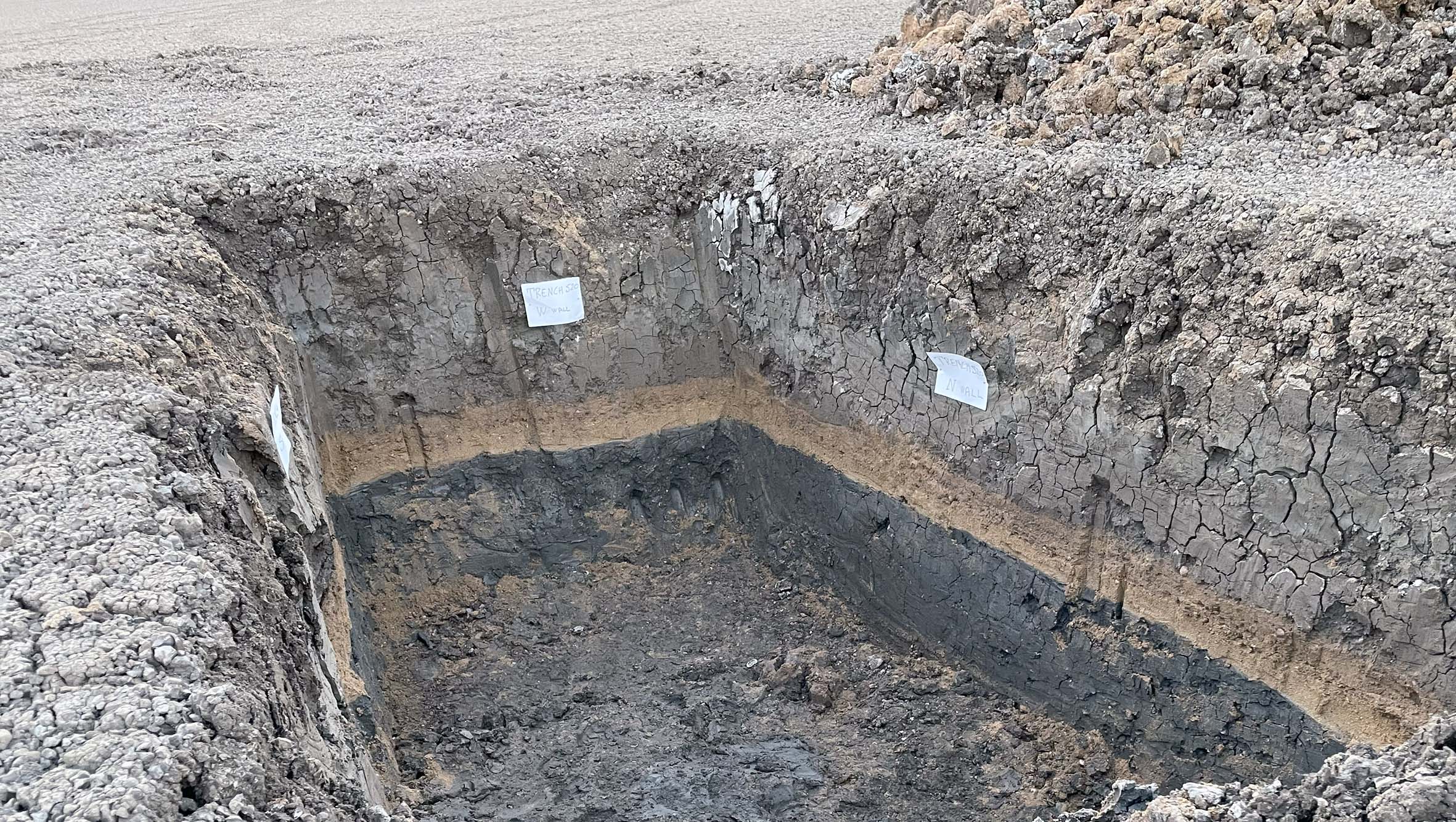
 The CE 365 paleotsunami deposit as recorded along the coast of SE Sicily, Italy (800 km far from the causative source in Crete, Greece)
About the Dataset
This database collects scientific data on paleotsunami deposits in the Euro-Mediterranean area. It aims to provide crucial information for tsunami hazard assessment and the development of inundation scenarios.
The data includes information on the location, stratigraphic characteristics, and dating of the deposits, offering a long-term view of the frequency and impact of tsunamis in the region. The first dataset included was produced in the framework of the EU-FP7 ASTARTE project.
Open Data Access (OGC WFS)
The dataset is freely accessible via standard OGC (Web Feature Service). You can download the complete data in various formats or connect directly using GIS software.
 The dataset is released under the Creative Commons Attribution 4.0 (CC BY 4.0) license. You are free to share and adapt the material for any purpose, provided you give appropriate credit.
Download the Full Dataset:
⬇️ Download CSV ⬇️ Download GeoJSON ⬇️ Download ShapefileFor GIS Software (e.g., QGIS, ArcGIS):
Use the following URL to add the WFS service to your GIS project:
https://services.tsunamidata.org/PALEOTSUNAMI/ows?service=WFS&request=GetCapabilities
How to Cite
If you use this dataset in your research, please cite it as follows:
De Martini, P. M., et al. (2017). The ASTARTE Paleotsunami Deposits data base-a web-based reference. Istituto Nazionale di Geofisica e Vulcanologia. https://doi.org/10.13127/tsunami/paleodeposits
Attributes dictionary
| Attribute name | Attribute description |
|---|---|
| name | Name of the Compiler of the record |
| sitename | Name of the investigation site quoted in literature or, if none a reasonable name from a nearby locality. |
| objectid | Identifier |
| yearinvestigationfrom | The age range of investigation of the site, from |
| yearinvestigationto | The age range of investigation of the site, to |
| country | Country of the site location |
| region | Region of the site location |
| province | Province of the site location |
| sitegeometry | Point if are reported results obtained from an individual point (e.g. a core), Area if are reported results from different observational points (e.g. several cores) |
| radius | When “Area” is selected the maximum extension of the area (radius in meters) is also reported |
| latitude | Latitude in degrees expressed as a decimal fraction (i.e., 00.0000 ); north is positive value |
| longitude | Longitude in degrees expressed as a decimal fraction (i.e., 00.0000 ); east is positive value |
| datum | Kind of datum: ED50, ETRF89, Roma40 or WGS84 |
| elevation | Elevation in meters of the site above (positive value) or below (negative value) the present sea level |
| elevationtype | GPS or Topographic map, unknown if not available |
| distance | Maximum distance in meters of the site from the present shoreline |
| timeall | Maximum age of the observed sequence (Yr BP) |
| numofevents | The number of tsunami events recognized in the site |
| sitedescription | The field provides a narrative on the site |
| sitenotes | The field provides additional information for the site description |
| timestamp | The filed provides the time of the data insertion |
| site_idsite | Identifier |
| reference_idsite | Identifier |
| authors | List of authors of the reference document |
| title | Title of the reference document |
| publication | Journal of the reference document |
| volume | Volume of the journal of the reference document |
| issue | Issue of the journal of the reference document |
| pages | Number of pages of the reference document |
| year | Year of publication of the reference document |
| doi | Digital identifier of the reference document |
| url | Uniform resource locator of the reference document |
| abstract | Abstract of the reference document |
| contactname | Contact author of the reference document |
| contactemail | E-mail contact of the author of the reference document |
| compiler_idsite | Identifier of the compiler |
| surname | Surname of the compiler |
| affiliation | Affiliation of the compiler |
| acronym | Acronym of the affiliation |
| email address of the compiler | |
| geomorphicsetting_idsite | Identifier |
| areaprotecteddunes | Option for geomorphic setting characterization |
| coastallake | Option for geomorphic setting characterization |
| coastalmarsh | Option for geomorphic setting characterization |
| estuary | Option for geomorphic setting characterization |
| fluvialplain | Option for geomorphic setting characterization |
| offshore | Option for geomorphic setting characterization |
| rockycoast | Option for geomorphic setting characterization |
| geomorphicsetting_other | The field provides additional information for the site geomorphic setting description |
| typeofsite_idsite | Identifier |
| artificialcut | Option for type of site identification |
| coast | Option for type of site identification |
| enginecore | Option for type of site identification |
| exploratorytrench | Option for type of site identification |
| handcore | Option for type of site identification |
| naturalexposure | Option for type of site identification |
| typeofsite_other | The field provides additional information for the site identification |
| event_idsite | Identifier |
| depth | The depth of the tsunami deposit in meters with respect to the present ground surface/sea bottom |
| thicknessordimension | The maximum value in meters of a tsunami layer or the max axis for blocks |
| evidencedescription | Free narrative on the process followed for the recognition of the tsunami deposit |
| labyoungestagelya | Numeric value of the youngest laboratory age as yr BP (before present) |
| lyastddev | Standard deviation Error of the laboratory youngest radiocarbon age |
| youngestcalagemin | Minimum youngest age as yr AD/BC (yr AD positive values and yr BC negative values). The field reports the dendrochronologically corrected age for Radiocarbon, historical/archeological estimates |
| youngestcalagemax | Maximum youngest age as yr AD/BC (yr AD positive values and yr BC negative values). The field reports the dendrochronologically corrected age for Radiocarbon, historical/archeological estimates |
| laboldestage | Numeric value of the oldest laboratory age as yr BP (before present) |
| loastddev | Standard deviation Error of the laboratory oldest radiocarbon age |
| oldestcalagemin | Minimum oldest age as yr AD/BC (yr AD positive values and yr BC negative values). The field reports the dendrochronologically corrected age for Radiocarbon, historical/archeological estimates |
| oldestcalagemax | Maximum oldest age as yr AD/BC (yr AD positive values and yr BC negative values). The field reports the dendrochronologically corrected age for Radiocarbon, historical/archeological estimates |
| preferredagemin | Minimum preferred ages for the tsunami (yr AD positive values and yr BC negative values) |
| preferredagemax | Maximum preferred ages for the tsunami (yr AD positive values and yr BC negative values) |
| historicalage | Year of a potential tsunamigenic earthquake/landslide/eruption occurred within the interval of the time defined for the tsunami (yr AD positive values and yr BC negative values) |
| eventdescription | Short discussion about the type of dated materials (if marine, it’s should be specify the Delta R), the position with respect to the tsunami deposit to be dated, pertinent problems and any information that is considered as relevant |
| eventnotes | The field reports additional information for the event description |
| event_idevent | Identifier |
| dating_idevent | Identifier |
| archaeological | Option for type of dating technique applied |
| cs137 | Option for type of dating technique applied |
| osl | Option for type of dating technique applied |
| paleontology | Option for type of dating technique applied |
| palynology | Option for type of dating technique applied |
| pb210 | Option for type of dating technique applied |
| radiocarbon | Option for type of dating technique applied |
| sedimentationrate | Option for type of dating technique applied |
| tephrachronology | Option for type of dating technique applied |
| thermoluminescence | Option for type of dating technique applied |
| dating_other | The field provides additional information for the dating technique applied |
| typeofanalysis_idevent | Identifier |
| environmental | Option for type of analysis applied |
| geochemical | Option for type of analysis applied |
| magnetic | Option for type of analysis applied |
| micromorphological | Option for type of analysis applied |
| paleontological | Option for type of analysis applied |
| sedimentological | Option for type of analysis applied |
| x_ray | Option for type of analysis applied |
| typeofanalysis_other | The field provides additional information for the analysis applied |
| typeofevidence_idevent | Identifier |
| geomorphology | Option for type of tsunami event evidence |
| sediment | Option for type of tsunami event evidence |
| transportedblock | Option for type of tsunami event evidence |
| typeofevidence_other | The field provides additional information for type of tsunami event evidence |
Legacy landing page
If you are looking for the legacy landing page hosted in ArcGIS Online, please, use the following link.